A small area of the Cubillas river basin (in the province of Granada) has been selected to carry out this project. The area in question slopes into the fertile plains of what is known as the Vega de Granada, which has been designated a “vulnerable zone” under the scope of the Nitrates Directive.
MAP OF THE AREA OF ACTION

JUSTIFICATION FOR CHOOSING THIS AREA.
The Cubillas river basin has the following characteristics:
- A continental Mediterranean climate, which has characteristically low rainfall (between 500-600 mm) that is concentrated in the spring and autumn seasons. In many cases, precipitations are torrential, particularly in the autumn. The summers are very hot and the winters very cold, with some snowfall.
- With mainly olive-growing areas and a rugged topography, the land offers considerable gradients and here we can find soil that has evolved very little on limestone, marl and dolomite. The soil here is usually poor; it has little organic content, is not very consolidated and has little vegetation on the surface, which makes it easier for the surface layer to be dragged away by the run-off waters, also facilitating the formation of rills and gullies.
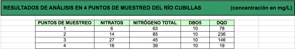
To verify the existence of a potential problem of water pollution in this area, analyses have been carried out at 4 different points along the Cubillas river. The results show that it is, in fact, a basin forming part of a zone that is vulnerable to contamination by nitrates from agriculture.
See Table of results of the analyses at the Cubillas river. Granada Provincial Council Environment Laboratory.
SELECTION PILOT PLOTS
In order to carry out the demonstrative experience, a surface area of 5 hectares of gullies located in the selected area of action has been defined.
The specific zone of action, within this area of work, has been defined by selecting plots of land owned by farmers in the area who are participating in the project through voluntary collaboration agreements. Several agricultural plots close to each other have been chosen, ensuring they are homogenous as regards slope, crop, farming practices, condition of plant cover and soil erosion, with at least one of these plots being used as a witness point.
")
")


